

SINGAPORE, 24 July 2023: This almost 8-kilometre path near Malaga (Andalusia) was once considered one of the most dangerous in the world.
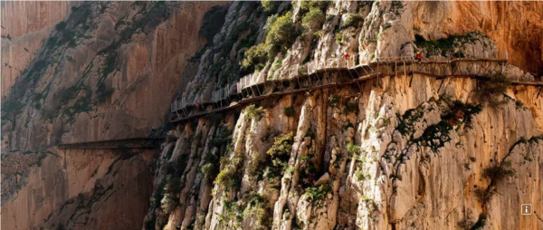
Today the entire route has been carefully restored, but although it’s now much safer, one thing hasn’t changed – the unique experience of strolling along walkways hanging over 100 metres on a sheer cliff face.
The Caminito del Rey route is spectacular from beginning to end, running through cliffs, canyons, and a large valley. It crosses the landscapes of Desfiladero de los Gaitanes, a gorge carved out by the river Guadalhorce, with walls 700 metres high. You will need to buy tickets for El Caminito del Rey, and you can reserve them on the official website.
What is the walk like?
The trail is linear and taken one way, going downwards and from north to south, some on mountain paths and some on suspended walkways. It’s 7.7 kilometres long and takes about 3-4 hours to walk, from the start in the town of Ardales to the exit in Álora. The reception area at the start has a restaurant and several parking areas and is also the shuttle bus’s final stop, which runs between the north and south ends of the trail.
This is the starting point of two paths which lead to the control cabin and the Gaitanejo dam, where the official trail of El Caminito del Rey begins. The longer is 2.7 kilometres, starting from Sillón del Rey, a set of stone benches, tables and chairs once used by Alfonso XIII, or through the tunnel next to the restaurant. The other path is shorter, just 1.5 kilometres starting with a smaller pedestrian tunnel 200 metres before the restaurant.
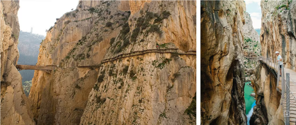
At the control cabin, personnel give visitors a protective helmet and check their shoes’ suitability. The viewing point on Gaitanejo Dam has views of the cave dwellings of Sierra Parda, which were once home to the staff working at the hydroelectric plant. After reaching the walkways, the trail continues through the Gaitanejo Gorge, the Tajo de las Palomas Canyon, and the Puente del Rey hanging bridge. The landscape gradually changes as you approach the Hoyo Valley with its leafy woodland.
Next, the path enters the spectacular gorge of Los Gaitanes via walkways suspended 100 metres above the ground. The amazing sights on this stretch include a hundred-year-old juniper tree growing among the rocks, the “fossil beach” with Jurassic-period fossils, and a glass balcony which sticks out from the walkway for those who feel they need to push their limits. The path continues to the final stretch: after handing back your helmets in the control cabin, there is a 2.1-kilometre walk down the hill to the railway station at El Chorro.
TIPS AND RECOMMENDATIONS
How to get there
Both the town of Ardales and El Chorro station can be reached by car from Málaga (in about 50 minutes), Ronda (60 km away) or Antequera (55 km). El Chorro-Caminito del Rey railway station is on the Málaga-Seville line, connecting to other towns like Ronda. The official website has helpful recommendations on routes, opening times, and how to get there.
Things to bear in mind
In addition to a general visit completed at your leisure, there is also the option of a guided tour to learn more about the region’s history, geography and biodiversity.I t’s advisable to bring water, a snack (chocolate, nuts, fruit, etc.), or a sandwich. The characteristics of the trail, between tall cliffs on walkways and bridges suspended at a great height, will make the hardiest walker dizzy. It is not recommended for anyone with a fear of heights.
The stretch, with the suspended walkways between the north and south control cabins, is 2.9 kilometres long. The rest of the walk comprises mountain paths and forest tracks between the control cabins and the entrance and exit to the path.
There is a tunnel running parallel to the walkways of the Desfiladero de los Gaitanes, which is an alternative to the aerial path on days when the wind and rain could cause mudslides. The tunnel is 300 metres long, of which 285 are inside, and 15 are outside in the Hoyo Valley.
What else is there to do?
You can make the most of your visit and explore the Guadalteba, Antequera and Guadalhorce Valley districts. If you fancy even more active tourism, many companies organise water activities in the reservoirs nearby, or you can walk part of the Gran Senda de Málaga path.
But if you prefer something more urban and cultural (or a dip in the sea, depending on the time of year), don’t forget that the city of Malaga is less than 50 kilometres away.
(Source: Spain Tourism Board – Southeast Asia, Australia & New Zealand)